
Durham Meadoway Visioning Study
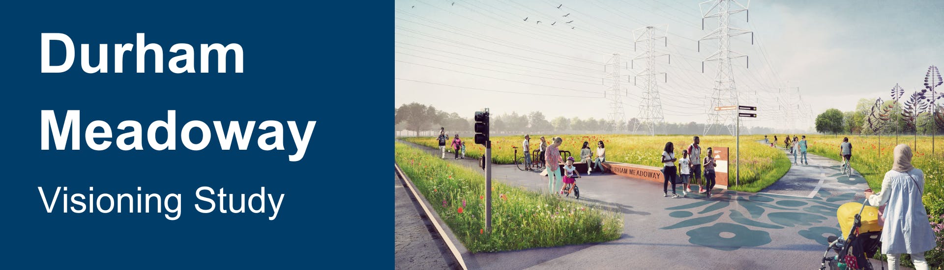
The Durham Meadoway is a proposed pedestrian and cycling route and linear park that will connect people to destinations across more than 30 kilometres of Durham Region. In addition to providing a significant east-west recreational facility and activity transportation spine, the Durham Meadoway also has the potential to become a multi-faceted space for people that includes ecological enhancements, public art and community amenities.
Don't forget to subscribe to this page to receive project updates by email.
What is the purpose of the study?
The Durham Meadoway Visioning Study will provide a robust vision and framework that will guide the future detailed planning and implementation of the corridor. The study will identify a functional (high-level) route for the multi-use trail and create a concept plan for the types of experiences, amenities, gateways, public art and other elements that community stakeholders would like to see programmed or evolve over time. The Visioning Study will be the first of several initiatives that will be needed to take the Durham Meadoway from concept to construction.
Phase 1 Public Open Houses
Two open houses were held as part of Phase 1 of the project.
- January 17 from 6 to 8 p.m. at Durham Regional Headquarters in Whitby.
- January 19 from 6 to 8 p.m. at Chestnut Hill Developments Recreation Centre.
The following materials were presented at the open houses to provide information about the project and seek input from the community on the vision, guiding principles and route options:
- Welcome
- Project timeline
- Case studies
- Vision
- Guiding Principles
- Setting the Primary Route
- Route Options (Note: this is a large file. An alternative version will be provided soon).
- Placemaking
What did we hear in Phase 1 of the study?
Read the Phase 1 Community Engagement Summary to learn more about how the project team has engaged the community in the visioning process.
Phase 2 Public Open House
An open house was held as part of Phase 2 of the project on April 26th at Durham Regional Headquarters in Whitby. The following materials were presented at the open house for public feedback:
Introduction
Route Option Evaluation
- Route Option Evaluation Overview
- Altona Road Crossing Evaluation
- Whites Road Crossing Evaluation
- Cherrywood Transformer Station Evaluation
- Highway 412 Crossing Evaluation
- East of Brock Route Route Evaluation
- Ashburn Road to Lynde Creek Route Evaluation
Draft Visualizations
- Eastern Gateway
- Typical Gateway
- Typical Gathering Space
- Typical Intersection
- Typical Road Crossing
- Typical Park Connection
- Wetland Interpretive Opportunity
- Whitby Focal Point
- Western Gateway
If you require the above materials in an accessible format, please contact planning@durham.ca.
View comments on the proposed route
Thank you for providing feedback on the proposed trail route for the Durham Meadoway. The commenting period for the interactive map was June 10 to July 17. Click the map below to view pinned comments and feedback.

Endorsement of Visioning Study
On March 20, 2024, the Durham Meadoway Visioning Study was presented to the Committee of Whole along with the Report #2024-COW-11 and a staff presentation. The recommendations from Report #2024-COW-11 were referred to staff during the Regional Council meeting on March 27.
A revised report, identified as Report #2024-COW-22, was prepared for the Committee of the Whole on June 12, 2024. This revised report included three options for funding and project management of the Durham Meadoway. The recommendations within Report #2024-COW-22 were then approved by the Regional Council on June 26.
Planning for the Preliminary Design Study of the Durham Meadoway trail and associated amenities is expected to start in 2025. This follows the development of a Memorandum of Understanding between the Region and the City of Pickering, Town of Ajax, Town of Whitby and City of Oshawa later in 2024. This memorandum will outline a framework for cost-sharing and project management.
Subscribers to the Durham Meadoway Visioning Study page on Your Durham will receive ongoing updates as the project progresses toward the design phase. Stay tuned for more news!
Phase 1 Public Open Houses - materials

Who's Listening
-
Principal Planner - Transportation Planning

Phase 2 Public Open House - materials
-
 Introduction
-
Route Option Evaluation
-
 Route Option Evaluation Overview (1.11 MB) (pdf)
-
Altona Road Crossing Evaluation (25.4 MB) (pdf)
-
Whites Road Crossing Evaluation (17.4 MB) (pdf)
-
Cherrywood Transformer Station Evaluation (1.53 MB) (pdf)
-
Highway 412 Crossing Evaluation (1.17 MB) (pdf)
-
East of Brock Road Route Evaluation (1.66 MB) (pdf)
-
Ashburn Road to Lynde Creek Route Evaluation (1.44 MB) (pdf)
-
-
Draft Visualizations
-
Eastern Gateway (1.16 MB) (pdf)
-
Typical Gateway (631 KB) (pdf)
-
Typical Gathering Space (738 KB) (pdf)
-
Typical Intersection (594 KB) (pdf)
-
Typical Road Crossing (682 KB) (pdf)
-
Typical Park Connection (1.58 MB) (pdf)
-
Wetland Interpretive Opportunity (857 KB) (pdf)
-
Whitby Focal Point (1.66 MB) (pdf)
-
Western Gateway (912 KB) (pdf)
-
-
Phase 2 Community Engagement Summary (787 KB) (pdf)
